

Designing a Climate-Ready Downtown on the Edge of the Atlantic
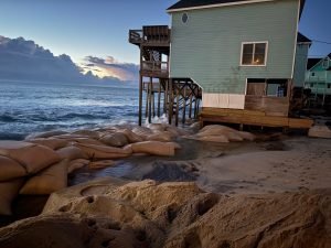 Manteo, a coastal town on North Carolina’s Outer Banks, is no stranger to water. With rain, wind tides, and king tides, sometimes the difference between a sunny day and a flooded street is as simple as which direction the wind blows. In recent years, the town has faced an increasingly urgent reality: sea levels are rising, storm surges are intensifying, and high tide flooding is no longer a rare event.
Instead of retreating or resigning, Manteo is designing a different future. Their journey is part of Climate Ready America’s Southeast regional demonstration, led by Geos Institute and supported by the Walmart Foundation. This initiative is proving how local leadership, paired with technical guidance from trained climate experts called Navigators, can shape climate resilience strategies that last.
The town partnered with the Coastal Dynamics Design Lab (CDDL) at NC State University and the North Carolina Department of Environmental Quality State Resilience Office – which is hosting a Climate Ready America Navigator, Helene Wetherington – to reimagine what climate resilience can look like. What began as a conversation about nuisance flooding has grown into a visionary initiative that could redefine the future of downtown Manteo and serve as a blueprint for other coastal towns across the country.
It started, as many good things do, with someone asking, “Are we thinking big enough?”
That someone was former Manteo Town Manager Melissa Dickerson, as she approached Holly White, a resilience planner with the State Resilience Office, at a conference and posed the question. “She said, ‘We are not thinking big enough about this, are we?'” Holly recalled. “I said, ‘No, I think you can go bigger.'”
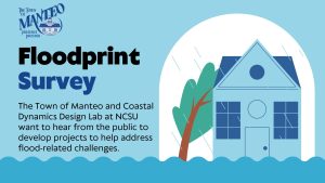 That simple exchange led to a surge of collaboration and possibility, eventually forming the backbone of what is now known as the Manteo Floodprint—a layered, visual, and community-informed guide that helps the town understand and plan for how water moves through its town.
With support from CDDL, students and faculty from NC State’s landscape architecture program created projections, designed concepts, and long-term adaptation strategies based on real-world data and input from the community. According to CDDL’s own research, a projected sea-level rise of three feet could inundate more than half of Roanoke Island and put over 650 structures at risk in the future.
That level of constant, creeping risk requires more than sandbags and pump systems. It demands a full shift in planning and design. Working with Climate Ready America Navigator Helene Wetherington and resilience planner Holly White, the Town of Manteo adopted a three-part process: strategic planning with elected officials, visioning and design through NC State’s CDDL studio, and the creation of the Floodprint itself.
“This is not just a design project,” White said. “We figured out a way for this Floodprint to meet the requirements of their Phase One and Two of the state’s Resilient Coastal Communities Program.” That alignment matters. By embedding the visioning work directly into the requirements of North Carolina’s RCCP, Manteo is now positioned to move straight into the design phase for climate resilience projects, skipping some of the bureaucratic delays that often slow small towns down.
“They will have completed Phase One and Two,” White explained. “And are eligible to move directly into design funding.” That is a significant win. It means that Manteo, a small town facing major climate risks, now has both a vision and a pathway to act on it. Even more importantly, it shows that thoughtful design and strategic partnerships can help communities get ahead of the curve, instead of constantly playing catch-up.
Helene’s role as a Navigator was not to draw the maps or write the plans; it was to connect the right people, elevate local leadership, and ensure that community-driven ideas could move from vision to implementation. Because the North Carolina Department of Environmental Quality’s State Resilience Office is a partner organization in Climate Ready America, a nationwide initiative led by the Geos Institute to help communities build climate resilience through locally rooted approaches, they can offer long-term, place-based support. “This is the power of having a Navigator,” resilience planner Holly White said. “Our job is to help communities think big, build the relationships, and unlock the support they need to act.”
Manteo’s Floodprint will not stop the impacts. But it does provide a clear-eyed, locally grounded, and beautifully envisioned roadmap for how to live with water. That is climate resilience in action. And in Manteo, it is already reshaping the future, one street and one partnership at a time.
Powered by Geos Institute
Learn how the Geos Institute provides backbone support and coordination for the Climate Ready America system.
Southeast Region
Learn more about our demonstration project in Florida, Georgia, North Carolina, and South Carolina.
 Robert Macnee, Ph.D. is Deputy Director of Resilience Services at Climate Resilience Consulting, where he helps governments, institutions, and communities reduce climate risk in equitable and practical ways. He holds a Ph.D. in Environmental Management focused on climate change impacts on health and communities, and brings over a decade of experience spanning economic development, resilience planning, and implementation.
 Samantha Medlock is President of Climate Risk Advisors, helping communities and organizations advance equity, sustainability, and resilience. Her career began chasing floods as a local official in Texas Flash Flood Alley—a hands-on experience that still shapes her approach to climate and disaster risk management.
 Jim is a multilingual world traveler. Based in Bavaria during the 1970s, Jim spent most of this period in India, Afghanistan and Nepal, where he founded and operated a charitable medical clinic serving Tibetan Refugees. He settled in Oregon in 1983 on a forested ranch in the Umpqua National Forest.
 Dr. Micah Hahn is an Associate Professor of Environmental Health in the Institute for Circumpolar Health Studies at the University of Alaska-Anchorage. She received her joint PhD in Epidemiology / Environment and Resources from the University of Wisconsin-Madison and her MPH in Global Environmental Health from Emory University. Subsequently, she was a postdoctoral fellow for the CDC Climate and Health Program, and in this position worked collaboratively with the CDC Division of Vector-borne Diseases and the National Center for Atmospheric Research. Her research focuses on understanding the health impacts of climate change and working with communities to develop locally-relevant adaptation and resilience-building strategies. Dr. Hahn is also on the Management Team of the Alaska Climate Adaptation Science Center.
 Michael is a former Founding Principal of Resilient Cities Catalyst, a global non-profit helping cities and their partners tackle their toughest challenges. He is currently the Executive Director of Climate Resilience Academy at the University of Miami.
 Dr. Quintus Jett is a consultant, educator, and strategist for public causes. He has a doctorate in Organizations & Management from Stanford University, and a two-decade faculty career which spans schools, departments, and programs of business, engineering, liberal studies, divinity, and public and nonprofit management. Following Hurricane Katrina in 2005, Dr. Jett launched a volunteer project in New Orleans, which enlisted residents, students from over a dozen colleges and universities, and hundreds of others to field map the city’s Gentilly district, Lower Ninth Ward, and New Orleans East. Dr. Jett is an innovator in higher education, bridging the divide between academic research and the other priorities of the modern university, including student access and diversity, community engagement, and providing foundations for life-long learning in today’s rapidly changing world.
 Scott is Monfort Professor of Atmospheric Science at Colorado State University. He has written about 100 publications in the peer-reviewed climate literature, is a former editor of the Journal of Climate, and served for five years as founding Science Chair of the North American Carbon Program.
 Linda has many years of experience in disaster preparedness and resilience. She has been an elected official on the Linn County Iowa Board of Supervisors, Chair of the Metropolitan Planning Organization, the East Central Iowa Council of Governments, the statewide Mental Health Developmental Disability and the Linn County Board of Health. Langston is a former president of the National Association of Counties (2013-2014).
 Ken works with families and organizations as a mediator, organizational consultant, trainer and facilitator. Along with his passion for helping people prepare for and reduce climate change, Ken also volunteers as a mediator through Mediation Works and is passionate about supporting youth through mentoring with Boys to Men of Southern Oregon.
 Matthew is a retired high school teacher who was once honored as Oregon High School Social Studies Teacher of the Year. Before his teaching career he was in the restaurant business in Portland. He is also a lawyer who has been a member of the Oregon State Bar Association since 1980.
 Andrea is the Resilience Policy Advisor for the North Carolina Office of Recovery and Resiliency. She works across state agencies and with local governments to increase the state’s resilience to the impacts of climate change.